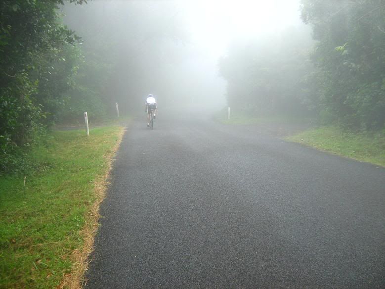
It's strange that I forgot to mention Saturday's trip to Springbrook. I ended up riding with a triathlete that I caught up to at Mudgeeraba, it was nice to have some company for the climb. Higher up, we encountered another group from the Kurrawa Surf club in Broadbeach. It's astonishing that while most cyclists on the Gold Coast don't attempt to ride to Best of All Lookout, this group from the surf club were doing just that. Unfortunately, their progress was halted when one of their group managed to crash somewhere on the climb.
We continued, but above 750 metres there were no views to be had as the mist had rolled in thickly. Yet it's days like these that make mountain climbs special in my view. The summit greeted us with the coolest temperature so far of -- just 17 degrees C. It had been 25 overnight on the coast. We ventured out to the lookout, just to confirm the anticipated white out, then returned to the lower altitudes for the final descent to the coast.
My regular riding partner Martin suggested overcoming "the nemesis" (a particularly nasty roller near Mudgeeraba) by staying in "The Dog", or the big chain ring. This usually works, but today the nemesis would find another way in, and I would break a pedal. I coasted along after this for a while, but broke it right off at Mudgeeraba. Luckily I was near enough to a bike shop to get the repair done quickly, but pedalling up the one hill in the village with one foot is an interesting experience. That done I mopped up the last few kilometres to get home.
* * * * * *
In a few short hours I fly out for the Alpine Classic, arguably among the hardest single-day rides in Australia. However, at present there is speculation that the 200km edition may be cancelled due to excessive temperatures on the weather forecast. If that's the case, I may be forced to ride the 130km edition in the morning, before tackling Mt Buffalo independently during the afternoon. Either way, it should be a great weekend. I can't wait.
Friday, October 31, 2014
Pedal mist out
Wednesday, October 29, 2014
How to Age a Map
 I promised to tell you how I aged the giant map in our parlor. I bought it at Books-a-Million for about $7. When I got it home, I took a very wet washcloth and went over the map several times, letting the water stand. I then sprinkled it with coffee grounds.
I let it dry and liked the way the paper crinkled and the coffee has made dark little 'age' spots, but it wasn't dark enough. So I brewed some tea bags in water and soaked the map with that, letting it stay on for a few minutes. I kept doing that until it was the aged color I wanted.
I took it to Hobby Lobby for framing telling them to just attach the map by the top. I didn't want the wrinkles to be pressed out. I thought it turned out quite old looking. Double click on it to see a closeup.
This could also be done with copies of photos or maps. Just experiment until you get the desired effect and have fun with it!
Sunday, October 26, 2014
Earth Hour Edinburgh

Switching off the lights on the Forth Rail Bridge, seen above in all its rusty-red splendour, was one of Edinburgh's civic contributions to Earth Hour yesterday. For some reason, this bridge is illuminated every night. Yes, it's a feat of 19th Century engineering - the world's first major steel bridge. No, we don't need to see it lit up at night.
During Earth Hour you would still have seen its partner road bridge illuminated in a ghastly orange glow reflected off the clouds.

These photos were taken by our intrepid Austrian friends right at the end of their round-Scotland bike trip in the summer.
In our household, we lit candles, turned off the lights and the TV and the computer(s). My husband and son were felled by sleep almost immediately - husband on the sofa, teenage son stretched out on the floor. My daughter and I looked at each other, sighed, and spent a peaceful hour reading by candlelight in a Jane Austen-ish way. Perhaps as a result of aligning body clocks to earlier darkness we were up with the sun this morning and on our way to the allotment by 8 a.m.
Saturday, October 25, 2014
Morrow Point Boat Tour - Black Canyon
Today seems like a perfect day to go back to Blue Mesa / Black Canyon and take the Morrow Point Boat tour.
We've been warned that the trail down has 236 steps down.
So we start the trek down - we don't need no stinkin stairmaster!

Once we reach the River it is anothermile orso to the Boat.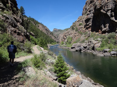
We had a picnic lunch before boarding and this chipmunk thought we might share
Here comes the 10 a.m. boat back. Time to turn around.
It is a ranger lead ride. It's a 41 Passenger boat and there are about 8 of us on board.
A different perspective from down here.
We pass a small waterfall. Chipeta Falls,drops about 150-160 feet off of the canyon wall.
According to Rudyard Kipling , who rode the train through the canyon in 1889: "We entered a gorge, remote from the sun, where the rocks were two thousand feet sheer, and where a rock splintered river roared and howled ten feet below a track which seemed to have been built on the simple principle of dropping miscellaneous dirt into the river and pinning a few rails a-top. There was a glory and a wonder and a mystery about the mad ride, which I felt keenly…until I had to offer prayers for the safety of the train" Avalanches and rock falls were common and an engineer and his crew never knew if or when their train would be the next to be swept into the icy waters of the Gunnison River.


Lush, Green Kokanee Bay is the turn-around point for the Boat Tour
The trail along the side of the river was the old Denver Rio Grande Western Railroad narrow gauge rail bed. The Curecanti Needle is a 700 hundred feet A-shaped rock formation that was part of the Rail Road's Logo.


The remains of a telegraph line in the rock
Hard to believe there was a rail road track once upon a time below the water.
The tour was 90 minutes and very informative. Now time for the hike back up
and up!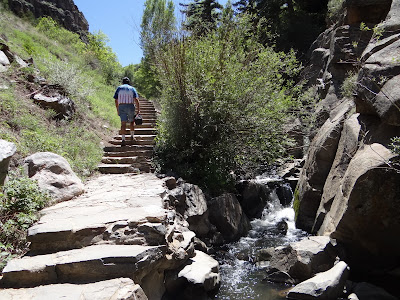
Till Later!
Meanwhile, we keep on Trek'n
Melissa, Gary & Tucson
We've been warned that the trail down has 236 steps down.
So we start the trek down - we don't need no stinkin stairmaster!
Once we reach the River it is anothermile orso to the Boat.
We had a picnic lunch before boarding and this chipmunk thought we might share
Here comes the 10 a.m. boat back. Time to turn around.
It is a ranger lead ride. It's a 41 Passenger boat and there are about 8 of us on board.
A different perspective from down here.
We pass a small waterfall. Chipeta Falls,drops about 150-160 feet off of the canyon wall.
According to Rudyard Kipling , who rode the train through the canyon in 1889: "We entered a gorge, remote from the sun, where the rocks were two thousand feet sheer, and where a rock splintered river roared and howled ten feet below a track which seemed to have been built on the simple principle of dropping miscellaneous dirt into the river and pinning a few rails a-top. There was a glory and a wonder and a mystery about the mad ride, which I felt keenly…until I had to offer prayers for the safety of the train" Avalanches and rock falls were common and an engineer and his crew never knew if or when their train would be the next to be swept into the icy waters of the Gunnison River.
Lush, Green Kokanee Bay is the turn-around point for the Boat Tour
The trail along the side of the river was the old Denver Rio Grande Western Railroad narrow gauge rail bed. The Curecanti Needle is a 700 hundred feet A-shaped rock formation that was part of the Rail Road's Logo.
The remains of a telegraph line in the rock
Hard to believe there was a rail road track once upon a time below the water.
The tour was 90 minutes and very informative. Now time for the hike back up
and up!
Till Later!
Meanwhile, we keep on Trek'n
Melissa, Gary & Tucson
Wednesday, October 22, 2014
Its Race Time

The mountain bike racing season is under way. Yesterday was the frist race of the season for the Psycowpath Mountain Bike Series. First on the schedule was Jewell Jam time trial.
The time trial was held at Jewell Park ion Bellevue, NE. The 3.5 mile course included some 450 feet of climbing. Temeratures were in the 80s during the race. (That's ride, 80s the end of March!)
Later in the day was the Old Towne Fat Tire Criterium. I had enough for the day standing 2 hours on the hillside at Jewell Park, so did not shoot photos during the crit.
Here's the link to the Time Trial photos.
http://win-photo.photoreflect.com
Swanson River City Shootout cross country race is this afternoon. Watch for posting of the photos.
Tuesday, October 21, 2014
Ballot paper

My ballot paper tonight, just before I put my pencil cross on it in the voting booth. Our son came with us to vote in his first UK parliamentary election. We explained to him beforehand that he would need to make sure he voted for the candidate he intended to, as some of the party names are very similar. The Scottish Labour Party, and the Socialist Labour Party. The Scottish Liberal Democrats and the Liberal Party in Scotland.
No, I'm not sitting up all night to watch the results. Tomorrow morning will be soon enough.
Sunday, October 19, 2014
Missing mountain
 In August I vowed to take a photo of one of my favourite stretches of the River Spey each time I was home. This is the shot from late October - yes, I'm a bit behind. If I hadn't decided on this sequence of photos I wouldn't have taken this shot, as the weather during our visit was grey and flat. Nothing remarkable here, just a little breeze dusking along the water, and the bad weather-to-come sign of Ben Rinnes having disappeared from view.
At least the gean trees (wild cherries) along the river bank shone out. Now the leaves will be gone.

The wooden cabin is a fishing hut, where the wealthy people who come to fish for salmon take shelter if the weather turns nasty. There's one thing at least money can't buy!
I am feeling pent up in the city just now. Life is streets and pavements and the orange glow of sodium lights. We had hoped for a walk at the weekend on our way down to Moffat to hear our daughter play in a concert, and drove up to the lonely road beside Talla Reservoir. But on an afternoon of gales and heavy rain, with the light fading by 3.30, and the reservoir dangerously high, we turned back when the car began to lift off the road going through a flooded patch. A wild, isolated road over high moorland, with no mobile phone reception, is not a place to get stuck. So the walk had to be postponed. Still, the Moffat concert made up for it. Rutter, Bach, Vivaldi and Corelli (the 'Christmas' concerto) in the stout red sandstone church was a good way to keep the elements at bay.
Tuesday, October 14, 2014
Cycling Project - farmhouse stop

On the long, flat run down from Tongue to Lairg the group stopped at a farmhouse and was invited in for a very welcome hot chocolate. It also happened to be feeding time for an orphaned lamb, and turns were taken at feeding it and holding it. It must have been rather well fed by the time it had been round the group.

Veteran's Day vs Memorial Day

Yesterday, one of my facebook friends posted a question: "Can I ask a question - a serious question - its a pet peeve of mine. We have two holidays that seem somewhat similar - Memorial Day when we remember our deceased and especially our deceased military. I remember at home the parade going over the Wisconsin River bridge and stopping while a floral wreath was lowered into the river in honor of the naval war dead.
And we have Veterans Day to honor our nations Veterans. Why do we find it necessary to have our Veterans celebrations in cemeteries? Aren't we mixing apples and oranges here? Shouldn't we be having these celebrations at places like VA Hospitals, and maybe at recruiting centers or military installations?"
This made me reflect and think a little.
Memorial Day once was called "Decoration Day". Its the day graves of those lost their lives in the service of our country. Originally, it was for those that fought the Civil War. After WW1, it was expanded to honor those died in all American wars.
Memorial Day was traditionally observed on May 30th. In 1971 it was recognized as a federal holiday on the last Monday in May.
Veteran's Day used to be called Armistice Day. It is celebrated to mark the armistice between the Allied Nations and Germany. That armistice was signed on signed at 11 am on November 11, 1918. In 1938, it was made a legal holiday.
I remember that on November 11th each year, school came to a halt before 11 am. We stood at our desks at 11 am, turned facing East (I think it was) and had a moment of silence in observance of the signing of the armistice.
From 1971 until 1978 it was celebrated on the Monday close to November 11. However, because of the historic significance, it is celebrated on November 11th. That helps focus attention to the reason for the holiday: A celebration to honor America's veterans for their patriotism, love of country, and willingness to serve and sacrifice for the common good.
So, the short answer is that is that Memorial Day is for remembering those who lost their lives in battle or as a result of battle. Veteran's Day is to celebrate ALL Americans that served honorably.
I can understand the confusion. In my thinking, we should be laying wreaths and flagging cemeteries in observance of Memorial Day. On Veteran's Day we should celebrate all that have served in our armed forces.
It is appropriate to celebrate Veteran's Day with free meals to veterans, but not on Memorial Day.
Yes, it would be appropriate to celebrate at places like VA Hospitals, but it is also appropriate to celebrate the lives of veterans have have been laid to rest.
Friday, October 10, 2014
Making a Mountain Out of a Molehill
 How Do You Do? Nice Day!
  Did you hear a noise?
  If I look this way
 Can you look that way?
 Did you see anything, Old Boy?
 There it is again.
 What is that man doing in my field?
 I say - You...yes...you!
 Clearing the field, tidying the molehills!
Thank-you for making a mountain
(of lovely graded-grains soil)
out of your molehills
Mr Mole.
It is time to get busy with the seedlings!
Wednesday, October 8, 2014
Middle Falls of the Pigeon River

As a follow up to yesterday's post showing one of the overlook views along the Middle Falls Trail, here is a photo of what awaits you at the end of the trail. Middle Falls, while not an overly tall waterfall, is nonetheless quite spectacular and definitely worth the 5 mile round-trip hike. The river makes a nice sweeping curve right before dropping over the ledge that is Middle Falls. This curve makes for sort of a "bowl" shape to the main part of the falls. It is one of my favorite waterfalls to photograph.
Saturday, October 4, 2014
Rutland Round 2 - Uppingham to Seaton
With Marta - 10 miles in warm dry weather, though the path near Eyebrook reservoir was muddy. Lunch at Lyddington.
We set off from Uppingham, walking along the Stockerston Road out of the town and taking this footpath to the right. It starts from a sort of lay-by on a bend in the road.
 |
| The sign's a bit hidden, but the map and instructions are clear here. |
For the first time in quite a while we saw lots of tortoiseshell butterflies on the thistle flowers.

The path is clearly marked as it goes through the fields and along the ridge, past a building marked on the map as a meteorological station, and along to Kings Hill Lodge farm, where it turns left to join the Stockerston Road again.
 |
| Views towards Wardley Wood |
 At the road we turned left and after a hundred yards or so, opposite some houses, we turned right along a bridleway towards Stoke Dry Wood. This goes up to the entrance to the wood, and continues just outside, so that we kept the wood edge on our right.
 |
| View of Eyebrook from corner of Stoke Wood |
The path continues round the wood, with the occasional waymarker. A footpath crossed our route and led into the wood - ignore this one. The track turns left, then in while right keeping to the high ground, eventually coming out by Manor Farm at the top of the hill in Stoke Dry. Here we turned right and walked downhill to the church.
 |
| St Andrews church,Stoke Dry with the window to the priest's room over the porch |
 |
| Steps up to the parvise or priest's room -rumours about conspirators of the gunpowder plot using the room seem to be without foundation, and the story that a local witch was imprisoned and starved in here are also unconfirmed. |
 |
| Martyrdom of St Edmund. The painting shows men wearing feather headdresses shooting bows and arrows, and has been taken to support the theory that the Vikings discovered North America two centuries before Columbus. |
For more discussion of this see this article.
After the church we walked down the hill and took the footpath to the left just before the entrance to the woodland around Eyebrook reservoir. The path hugs the fence, and was pretty muddy on this occasion.
 |
| Snack break by the water |
After the entrance gate to the Eyebrook area the path heads diagonally up hill through a field. There are great views of the water to the west from the gate in the opposite corner, and Stoke Dry can be seen in the distance to the north west.
 |
| Looking back towards Eye Brook Reservoir |
 |
| Stoke Dry church behind us |
 |
| The reservoir again |
The route now takes us down to the A6003. We managed to miss a slight turn to the left at the top of this section, but our mistake soon became obvious. At the road we turned right - the verge is fairly wide, and the road walk is only for a couple of hundred yards.
The path turns left at the tarmac road to a gas pressure control station on the other side of the road. A stile took us on to the path - mud again just here, and cows who did little more than lazily raise their heads and watch us.
We followed the yellow-painted post waymarkers over stiles and fields. There's a footbride into another field, which we crossed diagonally. After whiles and stiles we headed fro the farm buildings, and followed the waymarks to reach the road and turned left into Lyddington. Lovely lunch in the Old White Hart's garden before setting off on the final couple of miles.
 |
| Art in Lyddington |
We crossed the village green and followed the track to a stile. The path goes along the left-hand hedge and leads to a gateway on the left. In this field are the traces of the fishponds which were once used by the bishop's palace (the Bede House).
 |
| The medieval fishponds of Lyddington |
 |
| One of mine |
The path goes through the gateway and into a narrow field. We walked along this and over another stile. Then we turned right and followed the path straight up the hill. We continued to the end of field, then turned right and almost immediately left, walking with a ditch on the left and continuing until we reached the farm track by Grange farm. This leads up the hill and into Seaton, with glimpses of the Welland Valley viaduct to the right.
Subscribe to:
Posts (Atom)