Today we tackle the Alpine Loop which runs out of Lake City - it is a 65 mile scenic 4 wheel drive Loop that connects Lake City, Silverton and Ouray.I have posted quite a few pictures. Hope you enjoy them!
We take the scenic route out of Blue Mesa.

Lake San Cristobal sits just outside Lake City. Over 700 years ago, heavy rains, caused weak volcanic tuff and breccia to slide down Mesa Seco mountainside. TheSlumgullion earthflowblocked the Lake Fork of the Gunnison River and created Lake San Cristobal. This lake is the second largest natural lake in Colorado.

We passed by Cannibal Ridge and then came across this site commemorating the Alferd Packer Cannibal Alferd and 21 men set out from Utah to Colorado in search of gold. In January they met Chief Ouray who recommended they wait till spring due to the cold and snow in the mountains. He ignored Ouray's advice and convinced 5 others to continue on with him. The party became hopelessly lost and ran out of provisions. On April 16, 1874, Packer arrived alone at Los Pinos Indian Agency near Gunnison. Evidence convinced everyone that he had killed andeaten the others in his party to survive

We arrive at Lake City to commence our journey. We stop at the Visitors Center to get a map of what to see along the loop. The guy looks out at our Tracker and says "you can't drive that on the Alpine Loop - you need a 4WD vehicle. I tell him it is 4WD and he says that he has a Jeep Liberty and he has trouble getting through the passes. I don't mention that it's probably because he doesn't know how to drive.

Here's the start - hopefully our Jeep wanabee is up to the task.


Which way do we go?

A short detour to the Sherman townsite

Sherman prospered into the 1880's with mining of various ores. The prosperity lasted about 20 years and then the ore bodies all petered out. Today, all that's left of Sherman is a few broken down log
cabins, on private property

The road is starting to look a little more 4 wheel drive

and maybe home to some Big Horn sheep

We stop to try and do the Grizzly Gulch Trail which leads to the top of Handies Peak one of Colorado's 53 Fourtenners. It starts at 10,425 and ends at 14,048. It is said to be the easiest one and we're all about that !

The trailhead starts at the bridge

Meanders through tall pines
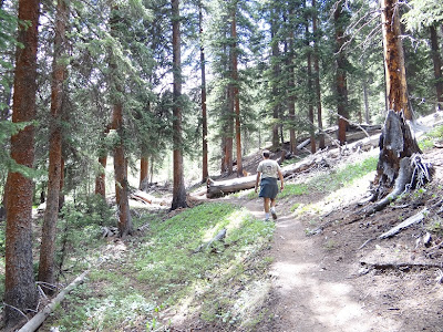
Offers some great views

We start to wonder - which peak is ours?

We get a mile or two and we hear some big kaboomers and dark clouds are rolling in - we think that maybe being at the top of a 14er isn't such a great idea during a thunderstorm and head back.

We get back to the car just as it lets go.

Fortunately it passes and we come to the American Basin.

This isone of the most scenic basins in the San Juan Mountains. In late July it is filled with wildflowers.
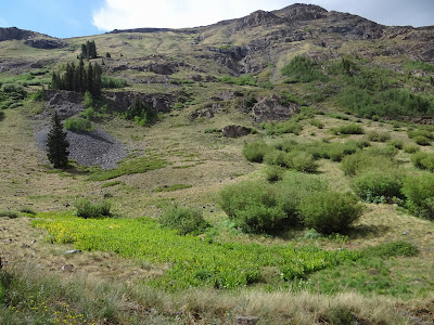
A few are starting to pop out


The road is getting rougher

and it's getting pretty winding.

When the marmots aren't falling into toilets they are sleeping in the middle of the road.

Tucson loves Marmots. "Marmots Mommy - Marmots!"

We arrive at Cinnamon Pass 12, 640 feet


Tucson enjoys the views

We see the remnants of an old mining town in the distance.

We wind our way down

It is Animas Forks. The first cabin was constructed in 1873. By 1876 it was a booming mining town. Again when mining profits declined it eventually became a ghost town by 1920

Hey I'm thirsty and this thing is empty!

It has fallen into ruins but there are still quite a few buildings remaining. We think about detouring to Silverton but we are only 1/2 way around the loop and it is getting late.

Next stop Engineer Pass

It's an uphill climb!

Looks like we're getting close

Made it! Engineer Pass, at 12,800 feet, is situated on the rim of two extinct volcanic
calderas.


The views are amazing

On our way back down Gary spots this house in the distance. What's so interesting about it?

The entry bridge of course

Next we come tothis cute oldCabin. The water is running to deep and swift to cross over for a better view.

Nearing the end of our drive we find Whitmore Falls.

At one time,Capitol Citywas predicted to be the capitol of Colorado, but today only a few structures remain from its heyday

We made it through the entire loop! On the way home I mentioned the odd noise the car was making on the road - Gary said it was just the road. I didn't remember it sounding that way on the way down and was just going to mention that it sounded more like a flat tire to me - when - Yep I was right. The Loop did in the tread on one of the original tires - good thing we had a spare!
 Till Later!Meanwhile, we keep on Trek'nMelissa, Gary & Tucson


